Viable News Team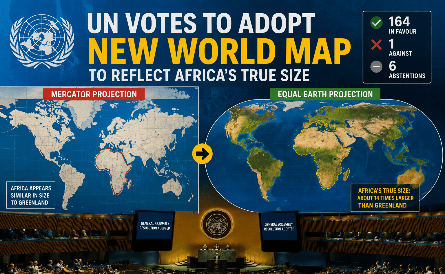
The United Nations General Assembly has overwhelmingly backed a resolution calling for a more accurate representation of the world’s continents, in a move aimed at addressing the distortions created by the widely used Mercator map projection.
The “Correct the Map: Rebalancing Global Cartographic Representation and Promoting Equitable World Maps” resolution was adopted on Friday, 4 September 2026, with 164 countries voting in favour, one against and six abstaining.
The initiative was championed by Togo and supported by African countries through the African Union. The African Union Commission welcomed the UN vote, describing it as an important step towards correcting long-standing distortions in how the world’s land masses are visually represented.
Why Africa looks smaller on many world maps
The issue centres on the Mercator projection, developed by Flemish cartographer Gerardus Mercator in the 16th century.
The projection was designed primarily to help with navigation. However, because of the way the spherical Earth is transferred onto a flat map, areas become increasingly distorted towards the poles.
This makes countries and continents in northern and southern latitudes appear much larger than they actually are, while regions closer to the Equator appear comparatively smaller.
Africa is particularly affected by the distortion. On commonly seen Mercator maps, Africa can appear closer in size to Greenland than it really is. In reality, Africa is roughly 14 times larger than Greenland.
The UN said the resolution seeks to encourage the use of cartographic representations that provide a more balanced understanding of the relative size of the world’s regions.
Equal Earth projection gains support
The resolution promotes the use of equal-area map projections, including the Equal Earth projection, which was developed in 2018.
Unlike the Mercator projection, Equal Earth is designed to preserve the relative area of land masses. This means Africa, South America and other regions near the Equator appear closer to their actual proportions.
The UN’s decision does not mean that every existing map will immediately disappear or that the Mercator projection has been legally banned.
The resolution is non-binding and instead encourages governments, educational institutions and other organisations to consider more accurate alternatives. The Mercator projection can also continue to be useful for specific purposes, particularly navigation.
United States votes against resolution
The resolution received overwhelming international support, but the United States was the only country to vote against it, while six countries abstained.
The vote represents a significant diplomatic victory for Togo and African countries that have pushed for a rethink of how global geography is presented.
Togo’s Foreign Minister Robert Dussey briefed journalists following the adoption, while UN records confirm that the General Assembly formally considered and adopted the resolution.
It’s More than just a map
Supporters of the initiative argue that the issue goes beyond cartography.
Maps are powerful educational and cultural tools, and the way continents are represented can influence how people perceive the size and importance of different parts of the world.
For African countries, the campaign has therefore become part of a broader conversation about representation, historical perceptions and challenging geographic distortions inherited from older mapping systems.
The African Union welcomed the resolution and said the initiative would contribute to a more equitable representation of the world’s geography.
The UN vote does not mean the world will wake up to identical new maps overnight. However, it gives international backing to efforts encouraging schools, governments, technology companies and other organisations to adopt maps that provide a more accurate picture of the relative size of Earth’s continents.
About the Author